March 17, 2012

Cat Peaks Loop

Today is St. Patrick's Day and everyone is thinking about green landscapes, even here in the Sonoran Desert. Although we don't have lush green meadows, I'm here to tell you that this desert is home to over 2,000 plant species, and they are ALIVE right now in the springtime! Here is a sampling from my hike earlier this week around the Cat Peaks of Usery Mountain Park:

Brittlebush
Hedgehog Cactus

Creosote
To get to the Meridian Trailhead where this hike begins, go due north along Meridian Road in Apache Junction until the road ends at a small dirt parking lot. Meridian Road can be accessed from metro Phoenix, either from US60 east to the Signal Butte exit going north off the freeway (left) and then east (right) on Lost Dutchman Blvd and north (left) on Meridian Road, or from the 202 Red Mountain Freeway to the Brown Road exit (which becomes Lost Dutchman Blvd) and head east (left) off the freeway and north (left) on Meridian Road.

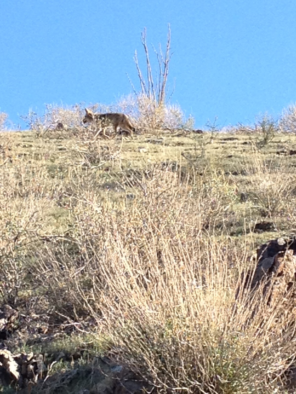
The trail starts at the northwest end of the Meridian Trailhead parking lot. From here, the goal is to cross over from the Tonto National Forest land to the Usery Mountain Park boundary. This section is the hardest route finding of the hike, but there is a clear (but unmarked) trail going down into and out of the ravine that will put you on the Pass Mountain trail. You can see the twin Cat Peaks southwest of the Meridian Trailhead so you will know that you want to keep veering to the left after the ravine and not make the mistake of going right and ending up on a 7-mile trek around Pass Mountain -- no no! I took a picture of the trail as it looks just a short distance from the Meridian Trailhead as it descends down into the ravine to cross over:


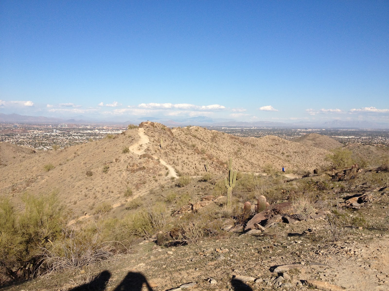
Once across the ravine, go left on the clear trail that you intersect with, and you will be on the Pass Mountain trail. Here's a park map to help you out: http://www.maricopa.gov/parks/usery/pdf/2012maps/usery-11x17-3d.pdf  Along the Pass Mountain trail, there is a fence on your left. When you get to the Cat Peaks, you will finally see some signage. There will be a break in the fence on your left, and you will be staring straight up at one of the Cat Peaks. You have a choice to go clockwise or counter-clockwise around these peaks. Either way is scenic -- we went clockwise this time, and then included the Cat Peaks Pass section so we could take in the views from the top. Wandering around these peaks looking for spring flowers isn't too much work because there are less than two miles of total trail mileage around and over them. After the peaks, we returned east along the Meridian Trail, and we turned north on Meridian Road to head back to the parking lot. Someone else clocked the hike for me with a GPS, and even with all of our wandering, we still came in at 4.4 miles of easy and beautiful spring hiking.

Length: 4.4 miles
Elevation gain: 300 feet
Time it took us: 2.2 hours
Dogs okay: yes
Fees: suggested $2 per hiker upon exit of the Meridian Trail at the self-pay station

March 3, 2012

Sutherland Trail

"Hi ho, hi ho, it's off to work we go . . . "

I remember the exact moment along the Sutherland Trail when my daughter told me that was her hiking song. I laughed at that because we all have songs going through our heads to get us through something monotonous. I told her that we use, "Ah, ha, ha, ha, stayin' alive, stayin' alive," for CPR compressions in the ER, and she thought that was hilarious.

Rarely do I pick a one-way, out and back trail to hike because I don't like the boredom of seeing the same terrain twice. The exception to this guideline is if there is a clear destination I'm trying to get to: such as, the view of Weaver's Needle on the crest of the Peralta Trail, the rock art at the end of the Hieroglyphics Trail, or the cave atop the Broadway Cave Trail. In the case of the Sutherland Trail in Catalina State Park, the clear destination was spring wildflowers. And WILD they are, if you go RIGHT NOW! Literally, hillsides of Mexican Gold Poppies with Lupines splashed in there for color.

From the trailhead parking lot, follow the signs that direct you left along the Sutherland Trail. Yes, the majority of people will be taking the Canyon Loop Trail -- I don't know why; I'm sure it's lovely, but if you're looking for wildflowers, then the Sutherland Trail is the one you want. You will be following a streambed, and, at times, crossing it. The trail splits off at a staircase, but you want to follow the clearly marked signs pointing you left along the Sutherland Trail and up a rock staircase. Shortly up these stairs, you will begin to see the wildflowers. We lingered a long  time in this area taking pictures like crazy by lying on the ground, posing on boulders, and annoying bees with close-ups.

While going up the second rock staircase, turn around to get shots of the flowers with Saguaros and Barrel Cacti in front. At the top of these second stairs, you have a choice to keep going along the Sutherland Trail, and other hikers did tell me that there were some more patches of flowers further along (the Sutherland Trail goes 10.6 miles up the side of Mt. Lemmon.) However, we were so enamored with this area of flowers that we elected to turn around at the top of the second staircase where there is an unmarked trail going hard-left off the Sutherland Trail (it forms a "V.") From here, you can do a loop around this heavily-flowered area to come back down the hill and reconnect with the Sutherland Trail to head back the way you came. In a sense, you are doing a counter-clockwise loop around the flower field. Cutting this hike off here at this point creates about 2.4 miles total of easy hiking that almost any flower-loving hiker can do. Hopefully, the blooms will keep up since it is still early in the season, but there's no telling so I'd go soon.

Length: 2.4 miles
Elevation gain: 200 feet
Time it took us: 2.5 hours with lots of photography
Dogs okay: yes
Fees: $7
Directions: The actual address to the park is: 11570 N. Oracle Rd. in Oro Valley. If at all possible, I highly recommend taking the Pinal Pioneer Parkway (Highway 79) to get to the park. From the far East Valley of metro Phoenix, this took me just over an hour and a half along this route. Along Hwy 79 past Florence, the wildflowers are absolutely gorgeous with Globe Mallows, Brittlebush, and Penstemons mixed in with the Poppies and Lupines, particularly between mile markers 105 and 106 and again between 112 and 113.


Poppies

Lupines

Rock Staircase

Streambed


The Lost Dutchman (I guess)


Hikers


Plan B: This photo was taken along Picture Rocks Road in Saguaro National Park where the blooms are just starting.

February 17, 2012

Urban Lakes: Red Mountain & Tempe Town Lakes

Great Blue Heron catching dinner at Tempe Town Lake
I miss being around water. Although many of the hikes that I've been posting about follow streams, lakes, and rivers, I still feel very landlocked here in the Arizona desert. I now realize how very much I took for granted growing up near the Pacific Ocean. Every birthday party, graduation party . . . even senior ditch day, took place at the beach. Exercise was . . . walking on the beach. Cooling off was . . . going to the beach. A nice meal out was . . . down by the beach. So I thought I'd post today about two places here that I like to go to find some expanse of water. Neither of these walks are particularly "hikes," but both make a really nice stroll; especially if you aren't into the rugged thing, but you just want some easy exercise.


Red Mountain Park Lake
Red Mountain Park Lake is just west of the 202 Red Mountain freeway along Brown Road in Mesa. The large and paved perimeter pathway around the lake is about 0.85 miles and very pleasant. My normal routine is to walk around the lake three times, and I can usually do this in about an hour making a 2.5 mile total walk. Along the way, there are people riding bikes, rollerblading, and fishing along the shore. I have also spotted many varieties of birds, especially different waterfowl, and rodents. Parking is super easy on either side of the park, and leashed dogs are allowed.
Tempe Town Lake is a man-made lake created by the damming of this section of the Salt River with inflatable dams. The way I like to do this lake is to park at Tempe Center for the Arts and begin the walk about 1.5 to 2 hours before sunset. If you begin at Tempe Center for the Arts, you will see a modern pedestrian footbridge going across the lake, but don't go over it yet! Instead, go due east towards Tempe Beach Park, and the old Mill Avenue Railroad Bridge will be the first bridge that you go underneath:


After going underneath the four Mill Avenue bridges, and past Tempe Beach Park with the rowers setting out for their before-sunset rows, you will continue along the path to the Rural Road (also called Scottsdale Road) combined pedestrian/vehicle bridge and turn left (north) over the bridge. Once on the other side of the bridge, turn left again (west) to begin forming a loop around the lake. Along the path coming down from the bridge, you might spot some people/trolls living underneath the bridge near some pygmy palm trees. Usually they are just sleeping. If you continue along the path, now due west, you will come to the marina:


Across the lake from the marina, you have good views of ASU and "A" Mountain with the lake in front. There is also public art along the path, and signage about the history of the lake and water usage. From the marina, under the four Mill Avenue Complex bridges, and then to the Tempe Center for the Arts footbridge is my favorite section if you are hitting this stretch just as the sun is setting. The whole loop is about 3.15 miles and well worth the walk if you are looking for water in the desert!


February 3, 2012

Beverly Canyon Loop

I have renamed this hike the "Fry's Electronics Hike" because the only real reason I decided to try it is because I needed to trek out to Fry's, and the trailhead is only a few blocks away. I make no secret of my preference for the desolation and lush vegetation of the Superstitions, but South Mountain has certain conveniences. Really, the Fry's Electronics theme is carried on right up to the trailhead parking lot which is next to an industrial park. I made sure to grab a parking space adjacent to the security kiosk for the warehouse figuring that the security guard might notice if my car was getting broken into . . . which would further the Fry's Electronics theme to, "Here's the place where I lost my purchases."

I have found, though, that some of my best hikes have been those that I have had the lowest expectations, and this hike is no exception. We have been blessed with some beautiful weather this winter, here in the desert, creating a somewhat early spring. We started the hike on the west side of the trailhead parking lot with the Javelina Trail, and not more than 200 feet up the trail did I find my first wildflower:

Mexican Gold Poppy

The flowers are just starting to bloom along the northern flanks of South Mountain along this portion of the Javelina Trail. A little further up the trail, we also saw some lupines and brittlebush just starting to bloom. Javelina Canyon is really lovely with birds singing on top of the saguaros, and on a Friday afternoon, we passed just a few other hikers. Every so often we would turn around and look north towards the Phoenix skyline and catch an airplane taking off or the bustle along the highways. We sat to break along the trail and noticed our dogs getting excited about something. We figured it was just a rodent or a lizard, but then we looked on the hillside above where we were sitting, and we caught three coyotes trotting along on their way down the canyon. I quickly grabbed my camera to catch the last one in the group:


At the top pf Javelina Canyon, you will turn left (east) along the Ridgeline Trail. There are some really great views from up here. The further you go, the more Phoenix landmarks become apparent, and soon you will be making out Camelback Mountain, the Papago Buttes, Usery Mountain, Four Peaks, and the Superstitions. The views are great! However, it is pretty steep in sections with loose-packed rocks, great for sliding while being pulled by two dogs. Next time, I will bring my mountain goat instead. I also noticed a lot more hikers along the Ridgeline section, and it seemed like they hiked this trail everyday, and I was just an obstacle in their path. I definitely got an "urban hiking" feel from this hike, and I can't imagine what it would be like on a Saturday. Here's a sample of a part of the Ridgeline section:


After coming down the last hill of the Ridgeline Trail, you will turn left (north) onto Beverly Canyon Trail which feels like a paved superhighway after what you just finished. There is also a LOT of traffic along the Beverly Canyon Trail, both hikers and mountain bikers, but you can move pretty quickly along here by just following the overhead power lines back to the trailhead. It was a nice shaded end to the hike, if you complete the hike in the afternoon.

Length: 3.9 miles
Elevation gain: 500 feet
Time it took us: 2.5 hours
Fees: none
Directions: From Baseline Road, go south on 46th Street to the end of the road.