January 26, 2011

Bulldog Canyon Loop

The Goldfield Mountains haven't gotten nearly the attention that the Superstition Mountains, with their famous "Flatiron" have gotten. It seems like everyone is familiar with the Superstitions. I still remember a newspaper article, years ago, where an Apache Junction couple found the late John Kennedy Jr.'s wallet while hiking in the Superstitions. The story was confirmed by Kennedy, and the couple were given a monetary reward and a big thank you from Kennedy. Who knew he hiked there, too? I have always felt bad for the Goldfield Mountains which border Apache Junction to the north and are just a few miles away from the Superstitions. The Goldfield Mountains are equally as scenic, but maybe not as high and as vast as the Superstition Mountains. Honestly, I think the Goldfields are possibly more scenic, and they are a geology nut's wonderland. The terrain is made up of rhyolite tuffs mixed with basalt layers and quartz latite and covered with colorful lichens. Back in 1971, the Geological Society of America decided to officially call this combination of layers the Geronimo Head Formation. Gold was found in veins of quartz around these mountains, and there are many abandoned mines out here; the most famous being the mine at the Goldfield Ghost Town. I picked up two pieces of quartz for my kids while hiking out here, but alas, neither had gold in them. I'm going to have to stick to my day job.

An easy Goldfield hike to start out with is the Bulldog Canyon Loop. I had heard that route-finding is difficult in the Goldfields because the trails are less traveled. I didn't find that to be true, and I would say that for most people, the biggest challenge will be driving to this Tonto Forest trailhead. I'm including photos here of some of the fuzzy route-finding areas. Hope this helps. I did this hike on a Wednesday late morning, and I didn't see another soul on the trail until the very end when a dirt bike passed me. You will have solitude, but my cellphone worked for most parts of the trail.

The Bulldog Canyon Loop starts at the Dome Mountain trailhead. If you are coming from metro Phoenix, then you will exit US 60 at Idaho Road and head north. Continue heading north on Idaho Road and do NOT turn at the intersection for AZ 88. At McKellips, turn right and head east. At Wolverine Pass, turn left and head north. At Tonto Street, turn right and head east. At Cactus Road, turn left and head north. At McDowell, turn right and go east until you reach the trailhead, which is straight ahead after the road bends north. There is a large dirt parking lot at the trailhead.

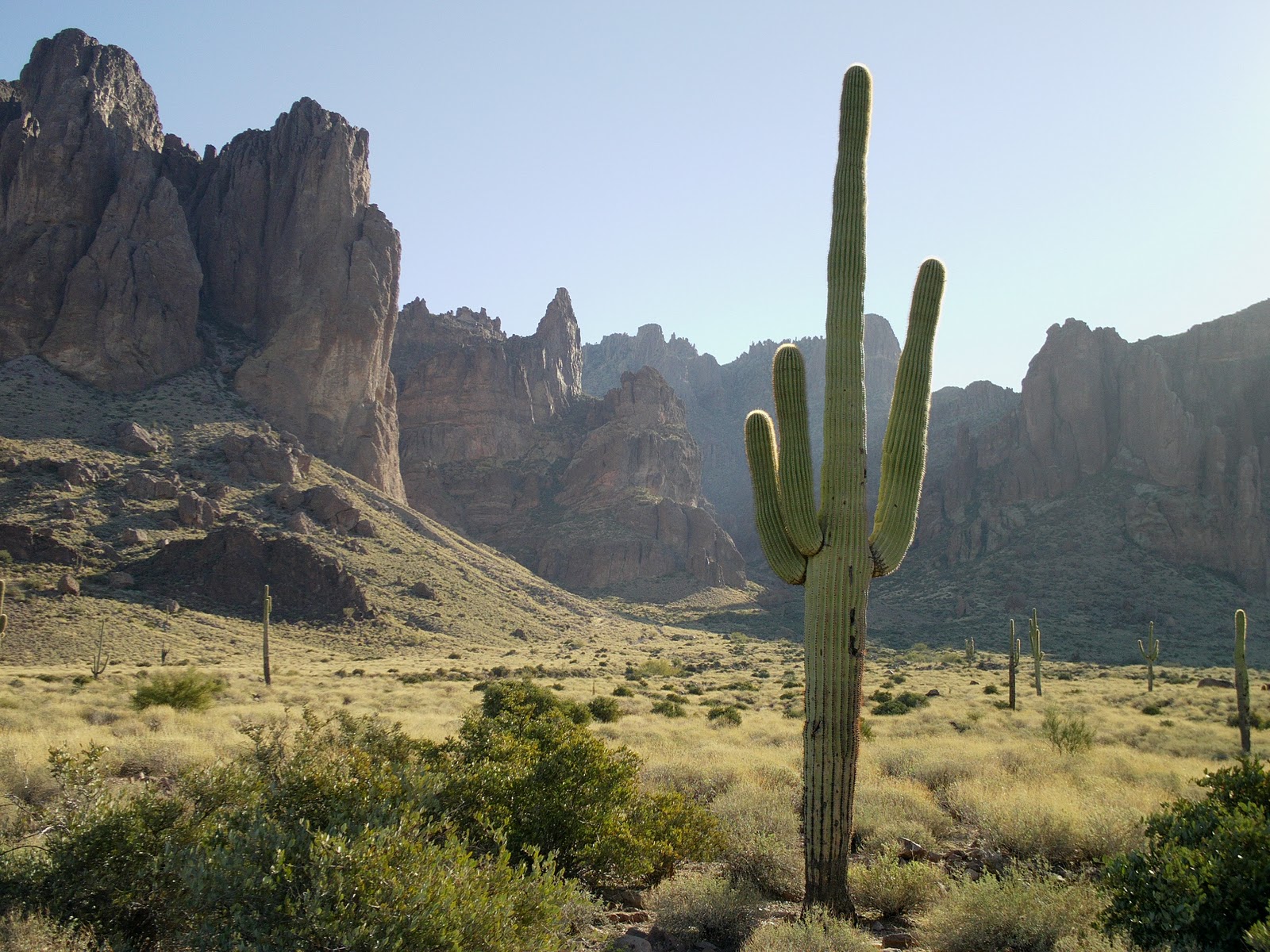
The trail around Bulldog Canyon starts on Forest Service Road 10 (FS 10) heading north. You are following a dirt road here. At the split, bear right on Forest Service Road 1356 (FS 1356.) These forest service roads are labeled with their numbers on brown sign posts. At this point, it becomes a little difficult to follow FS1356 because there are ATV roads crossing over your road. Just keep trying to follow the most road-like road which will be heading northeast and climbing gently uphill with a ravine on your left. You will know that you are on the right track when you get to the top of the hill, and you are rewarded with this view of Dome Mountain and and the adjoining peaks:


In this photo, you can also see where the road divides, and you can turn right and follow FS 1356, or you can turn left on an unmarked road. You want to turn LEFT here and follow the road that is now heading northwest. You are beginning to make your loop where you are always going to be bearing left to get around the big dark mountain on your left. If you continue bearing to the left on this road, pretty soon you will find yourself walking in a stream-bed. Technically, you could stay walking in his stream-bed, but there is a convenient trail that winds in and out of the stream-bed and allows you to avoid some deep sand and thorny bushes. Here is what the first sight of  this convenient trail out of the stream-bed looks like:


We also had the handy advantage of following piles of horse poop on this trail so even with the winding nature, we still knew we were on the right track. If you've followed this trail correctly into the canyon, then you will end up at an area of pools of water that look like a big slick of lava hardened here:


Here's where you want to look up and to the right (northwest), on the high cliffs above, where you can see the Mask Arches. One arch looks like it has a Saguaro growing through it:


Continue following this stream-bed down until you will leave Bulldog Canyon via a defined trail bearing off to the left. Again, you will be following a trail around a stream-bed. Here's a landmark:


Just about the time that you are sick of walking in sand that looks like this (pretty but slow walking):


Now, you will intersect back with with FS 10, and you will want to leave the stream-bed of thorny bushes and bear left up the dirt road:


You will follow FS 10 all the way back to the trailhead parking lot (about 1.5 miles from here.) Along the way are great views of the Superstitions all the way to Weaver's Needle to the east. Looking south on a clear day are views of the San Tan Mountains. 

Length: 4.7 miles
Elevation gain: 600 feet
Time it took us: 3 hours with photo stops & route finding
Dogs okay: Yes
Fees: none


January 18, 2011

Hackberry Springs Loop

There are a lot of fun hikes off the First Water Trailhead, but the Hackberry Springs Loop has many, really great features: mountain views, Indian ruins, a cholla forest, a natural water spring, creek walking, shade trees, a slot canyon, an old windmill, and an abandoned cattle ranch. Truly, you can't go wrong with any of the First Water Trailhead hikes with their rolling hills and creeks, but Hackberry Springs is really special. I almost don't want to share information about this hike so it doesn't get spoiled, but my hope is that if more people become enamored with the open spaces in Arizona, then more people will also be committed to preserving them, and we can avoid more scenarios like last year's mass closures of Arizona state parks. Preserve Arizona Outdoors!

To get to the First Water Trailhead from metro Phoenix, take US 60 east to the Idaho Road exit and head north. At the intersection of Idaho Road and Highway 88, turn right and head northeast on Highway 88 towards Canyon Lake. The First Water Trailhead is a right turn at Forest Road 78 after milepost 201. After you pass Lost Dutchman State Park, you will want to stop taking in the view to the right of the mountain, and start looking to the right of the road for the First Water Trailhead turn-off. After turning off, the actual trailhead is about 2 miles down the dirt road which is passable at most times of the year without a 4-wheel drive vehicle.

You will start off hiking on the First Water Trail. At the first intersection, turn left and head north on the Second Water Trail. When you come to the sign for the Black Mesa trail, look behind it, and you will see the remains of an old Indian ruin. We looked around for a bit, and it seems clear that this was some sort of stone house with grinding holes and little red pottery shards on the ground around it. At this intersection, you have some choices, and this can get confusing. You DON'T want to take the Black Mesa Trail. You want to bear to the left and head west on a trail that goes through a flat area of thick cholla with dark red soil. This area is called Garden Valley. Be on alert for cactus needles in the trail. From here, you will start to climb uphill until you reach a saddle where the trail drops down and around a canyon. Be careful, since this part of the trail has a lot of loose rock and can be slippery. After you have come down through the canyon, you will be faced with another big decision where the trail clearly splits off in two directions when faced with the big hill in front of you that is Hackberry Mesa. If you follow this trail to the left, you will see First Water Ranch in the distance. You DO NOT want to go to the left at this time since you will miss Hackberry Springs. Instead, bear right at the little rock cairn and head downhill and then gently to the left following the trail. When you get to a thick area of Mesquite trees and grass, then you'll want to just keep bearing left on the trail. Here's a photo of this area:


From here, you will start to see a creek on your right, and if you have come after a recent rainfall, there could be quite a bit of water in there. After you have crossed the creek once at a narrow portion with boulders around it, you walk a little further, and you will be faced with a wide, gravelly creek-bed and a sheer canyon wall in front of you. If you look straight at the rock wall in front of you, there is a small path that leads up to Hackberry Springs. You are looking for a small pipe coming out of the rock face with water gently trickling out of it. This is the spring. Here's what you're looking for:


The spring makes a nice place to rest and have some lunch since it is quite a bit cooler down here. To get back to the trail, follow the creek southwest again, and the trail will present itself on the left out of the creek-bed. From here, you are boulder hopping again through the creek. Just keep following the creek and the narrow canyon, and you will get out of here. My kids liked this part of the trail the best. Check out this next photo, and yes, the trail DOES go between those big boulders:


You will continue to follow this creek all the way to First Water Ranch and it makes for some beautiful hiking:

         
Today, First Water Ranch mostly looks like an old horse corral with an old windmill next to it, but in the early 1900s, it was one of three nearby ranches owned by cattleman William "Tex" Barkley. This spot also makes a nice spot to rest under the shade canopy. On the southwest edge of the ranch property, behind the water tower, there is a steep dirt road going uphill that will connect you with the horse parking lot along Forest Road 78 (you passed it when you drove in.) Take this road up to the top and turn around to look back at a great view of Four Peaks with the ranch down below. Back at Forest Road 78, turn left and follow this road back to the trailhead parking lot.

Length: 5.2 miles
Elevation gain: 700 feet
Time it took us: 4 hours with a lunch stop at the spring
Dogs okay: Yes
Fees: No Tonto Pass required at this trailhead (at this time)

January 11, 2011

Butcher Jones Trail

There were two main reasons why I was itching to try this hike. One, was that I had heard that on weekends and during the warmer spring, summer, and fall months, the trail becomes jam-packed with crazy lake-goers and trash so we had the fact that it was midweek and winter going for us. The other reason was purely selfish in that I wanted to check out two popular kayaking places: the lower Salt River from Pebble Beach to Granite Reef where the river never gets more than a Class II rapid, and Saguaro Lake where the Butcher Jones area and the eastern arm are closed to motorized boats. I have to say that even though it was midweek and winter, we still passed several large groups of "seasoned" hikers, some were even wearing nametags, so we didn't exactly escape the crowds on this popular hike. On the plus side, I only saw one kayaker on the lake and no boat traffic! Amazing! I will definitely go back here to kayak on another midweek day.

The Butcher Jones turn-off is off of Bush Highway. There are various ways to get there depending on where you are coming from: Hwy 87 or the 202 freeway, but since we were all coming from the East Valley, we took the Ellsworth Road approach and met at the QuickTrip on Ellsworth and University. Just a word of caution: you need to buy a Tonto Pass ahead of time! They are NOT sold at the Butcher Jones area! Here is a link to places that sell the Tonto Pass: Tonto National Forest Passes. The pass costs $6, and you must display it to park. If you are heading north on Ellsworth, it will turn into Usery Pass Road, and then you will turn right at the stop sign for Bush Highway. You will pass the Saguaro Lake Marina turn-off before making a right onto Butcher Jones Road (Butcher Jones Road is just north of the marina turn-off.) There is a nice, shaded picnic area here with tables, grills, and bathrooms. The actual trailhead is next to the lake on the left side of the cove.

The trail meanders alongside the dock for a bit before turning in and following a lake arm through a marshy area with shade trees, reeds, and lots of waterfowl. Bring your camera! From here the trail continues along the lakeside, and goes up over a hill where you can get sweeping views of the canyon walls that carve the lake and the surrounding mountains. We were even able to see the Flatiron of the Superstition Mountains from this vantage. Down below, we could make out nesting Bald Eagles in the trees along the lake. A good pair of binoculars would come in handy on this hike. There are some side trails that offer lake access, but we continued along the Butcher Jones trail and began to turn away from the shore and over some classic desert terrain. At the top of the hill, the wind kicks up, and you can see views of Four Peaks in the Mazatzal Mountains clearly to the northeast. A recent snowfall left some snow still on these peaks, and they were gorgeous at 7657 feet, rising above views of the lake in front of us. This part of the lake is called Burro Cove, and it makes a nice spot to stop and take pictures and have a snack, before turning around and heading back out the way you came in. The total round trip, out and back is listed as 5 miles, but it feels much shorter to me, probably because of all the great views.

Length: 5 miles
Elevation gain: 400 feet
Time it took us: 3 hours with lots of photo stops
Dogs okay: Yes on the trail, No on the beach
Fees: $6 for a Tonto Pass (must pre-purchase)

January 4, 2011

Jacob's Crosscut Trail

This hike was our first attempt at a "shuttle hike" where you leave one car at each end of the trail so you don't have to make a round trip hike. The total trail is 6.5 miles if you take it from the First Water Trailhead parking lot to the Broadway Trailhead parking lot; however, we were curious about the new McKellips Trailhead (near the Mining Camp Restaurant) so we shortened the hike just a bit. This hike was also our first realization that we have no way of calculating our own mileage on our hikes; so as a disclaimer: we are not your high-tech hiking blog destination! This blog is for the layperson hiker, to give you the real story. We follow multiple hiking books and websites to get trail information, and we cross-reference them all when we're out there. We have good old-fashioned compasses and basic scout navigation skills, but all mileage and elevation references are approximations. On many hikes, we also travel with kids and dogs so when I say, "It took us 4 hours to complete the hike," it might take you 2 hours, especially if your dogs have been training for the Iditarod. I'm considering a handheld GPS in the future (I'll take recommendations), but after looking at them, I decided I need to master texting and my cellphone first, before taking on the Big Guns.

We started out by leaving one car at the Broadway Trailhead which has parking for about 6 vehicles total so get there early. We arrived around 9:30 on a Tuesday, and there were 2 other cars in the trailhead lot. I think you would have to go down Broadway a few hundred feet if the lot were full because there are "No Parking" signs directly below the lot. The area around the Broadway Trailhead is a subdivision of pricey, "semi-custom" homes. We watched them build these homes over the years, and it is amazing how much development there is now near this part of the Superstition Mountains. If you're coming from metro Phoenix, then you'll want to exit US 60 at Mountain View and head north. Turn east on Broadway and follow it to the end. The trailhead and parking lot will be on your left. Don't expect great signage; you're looking for a block wall fence and some gravel. Now, after leaving one car here, you're going to go back west on Broadway to Mountain View, and turn right so you will continue heading north. At Superstition Blvd turn left and head west. At Apache Trail/Hwy 88 turn right and head north again. To get to the McKellips Trailhead, turn right at Nodak where you will see a large sign for the Mining Camp Restaurant (if you end up at Lost Dutchman State Park, then you have gone too far on Hwy 88.) Take a quick left at McKellips and follow it to the end; this is a dirt road that was passable in our minivan up until the last part, which seemed too rocky so we parked along the road and didn't see any "No Parking" signs.

After leaving the car, it was a bit difficult to find the actual trailhead, but you'll want to go due north from the parking area, through an opening in the fence (set up for hikers we assume) and follow the little path through the wash and past some houses until you see a defined trail. This part was interesting and reminded me of hikes I took in Switzerland where the trail was literally flush with the homeowner's backyard. I want to live in a house where you have to hike in to get there! Anyway, this path will lead you to a large sign which is . . . blank! This is the meet-up point with the Siphon Draw Trail that originates at Lost Dutchman State Park. A few paces away from the blank sign, there is another point of small confusion, where the Jacob's Crosscut Trail crosses the Siphon Draw Trail. The brown sign points up to Siphon Draw, and left to Jacob's Crosscut. There is no labeling on the sign for a right turn. But we are clever folks, and figured out that this was a four-way intersection so we followed the trail right (mostly south and a little west at this point.) This was a gamble that paid off for us because it is, in fact, the southbound route of Jacob's Crosscut Trail.

Once on Jacob's Crosscut Trail heading south, you will be looking west at views of Apache Junction and all the way out to Phoenix on a clear day. To the east are the Superstition Mountains which have a completely different look to them when you are this close up. I have seen this trail called the "Western Foothills" in some guidebooks, and the trail meanders over hill and dale, like foothills. This is a great trail for wildflowers in the spring, but I imagine it is also a great place for snakes because there is a lot of brush. We didn't see any wildlife this time of year (January.) About halfway through the trail, the scenery changes to ginormous boulders. Things get more rocky, and then you will drop down into a ravine and cross a very large wash. I had visions of all these giant boulders rolling down in an avalanche. Luckily, I think I missed that show by a few thousand years. Soon saguaros are popping up everywhere along the trail. When I first moved to Arizona, we took a trip to Saguaro National Park in Tucson, which I think is funny now because there seems to be a more dense forest of saguaro cacti here along the southwestern side of the Superstitions, than there are in the national park. You can also see these saguaros from US 60 when you are heading east. The trail is all loose rocks at this point, and can be difficult to navigate. You'll want to follow the trail with the "most" loose rocks on it. Frankly, this is my least-favorite part of the trail because it's hard to walk on, but you are less than one mile from the end, and there are some awesome views of Silly Mountain south from here. A side trip can also be made from here to Broadway Cave which is easily visible to the east on the side of the mountain. When you get to the "Y" intersection for the Lost Goldmine Trail you are just 0.5 mile from the end. You will start to see the backside of the pricey homes as you follow the Jacob's Crosscut Trail to the Broadway Trailhead where you left your car. Don't forget to go pick up car #2 while you drive past the entire mountain that you just traversed!

Length: 5 miles from McKellips Trailhead to Broadway Trailhead
Elevation gain: 200 feet
Time it took us: 3 hours with car shuttling
Dogs okay: Yes
Fees: No Tonto Pass required at these parking areas (at this time)